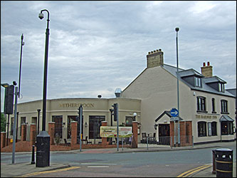
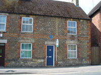
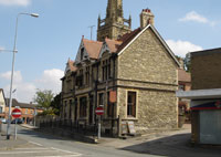
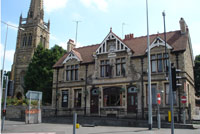
Starting at Duck Street Car Park, turn left, continue along Duck Street to High Street. On the corner is 'The Railway Inn' renamed following the arrival of the railway in 1893, previously 'The New Inn'.
|
1
|
 |
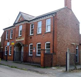
| Just south of the junction, in High Street, is Lloyds Bank. One of the grand financial buildings opened during the rise of the footwear industry.
|
2
|
 |
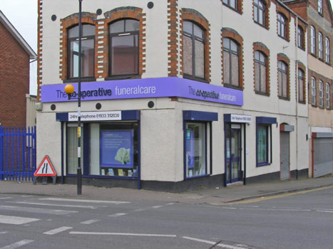
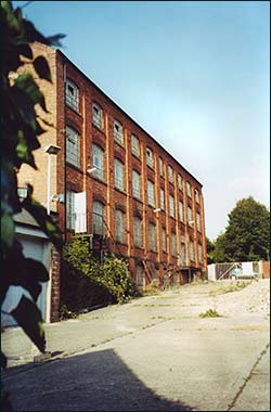
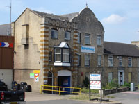
| Continue north along High Street, and on the corner of Station Road is the former factory of Sanders and Sanders, now the Co-op Funeral Service. Sanders and Sanders moved to Spencer Road in 1908. |
3
|
 |
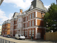
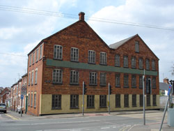
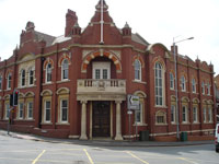
| Another 100 yards along High Street, on the right, is Queen Victoria Court. The main building was formerly the Queen Victoria Hotel, completed in 1899 at the cost of £12,000 and despite strong objections from the Temperance Society and local Non-Conformists. In the Rushden air raid of October 1940, the right hand turret of the roof was destroyed. It was rebuilt in 1955. |
|
 |
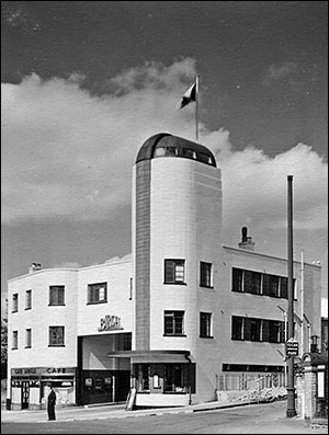
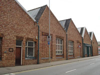
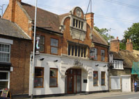
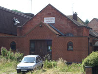
A further 100 yards, on the north corner of Shirley Road, is the former Birch Bros. Coach Station. The coach station was built in 1937 and Birch Bros gave Rushden a regular and punctual service to Bedford and London. In 1938 the cost of a day return ticket to London was 5s.9d. (about 29p)
|
5
|
 |
| Turn up Shirley Road. At the junction with North Street can be seen on the right the former Electricity Supply building, beyond which was a garage used by John White's transport, and beyond that the former factory of Nurrish & Pallett. |
6
|
 |
Turn right into North Street. At the front of the Police Station are the lamps from the former Police Station.
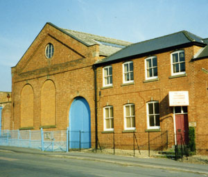
Continue along North Street and take the path across the railway line. On the right is the home of Rushden Historical Transport Society's museum. |
7
|
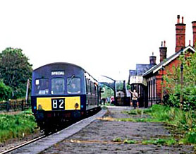 |
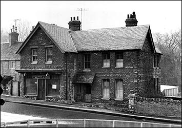
The Railway Station. The Midland Railway opened the branch line from Wellingborough for goods and mineral traffic on September 1st 1893. Passenger services started in 1894 and continued until June 13th 1959. The front of the building is beyond, in Station Approach.
|
8
|
 |
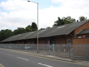
On the opposite side of the road (now John Clark Way) is the former Railway Goods Shed, (currently for sale - 2015) and the Rushden Historical Transport Society is trying to raise funds to save the building.
|
9
|
 |
| Turn left opposite the Railway Station, south along Rectory Road. After about 100 yards, on the left, is East Grove with the former factory of Messrs Phipps and Co. |
10
|
 |
Turn left into Victoria Road. Immediately on the left is the old Telephone Exchange.
|
11
|
 |
100 yards further up Victoria Road, on the right, is The Drill Hall built in 1928.
|
12
|
 |
| Return down Victoria Road, and opposite the Telephone Exchange on the corner of Rectory Road stands the former boot factory of Joseph Knight. He was here from 1893 until he moved to York Road in 1908. This factory was taken over by F England Smith & Co, until 1930 when A W Head & Co, leather factors and merchants moved in. |
13
|
 |
Turn left into Rectory Road and on that corner is the former Boot & Shoe School, and the former Coxton Shoe Co. the latter being taken over by the Evening Telegraph works in the 1960s.
|
14
|
 |
| 75 yards further along Rectory Road, on the corner of Albert Road, is the former factory of Ebenezer Claridge, later taken over by the Denton Brothers and currently Silver Reed sewing machines. |
|
 |
| At the junction with Queen Street the former Salvation Army Barracks once stood. The building was demolished in 1949 for road widening, and the Salvation Army took over the former Congregational Church in Church Street, where they still have a citadel, charity shop, and cafe. |
16
|
 |
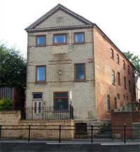
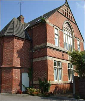
| Cross the junction with Queen Street, and after 25 yards on the left upto the corner of Portland Road, is the facade of the former office block of the Co-op (CWS) Boot & Shoe Factory built in 1901. The Office Block, pictured here, was built in 1903, and its facade is now listed. The main factory which stood behind was demolished and replaced with housing in the 1970s. [now converted into luxury flats] |
17
|
 |
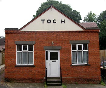
Turn into Portland Road and immediately on the right is a bunglaow.
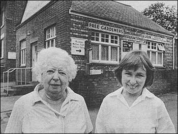 This formerly belonged to the Free Gardeners Friendly Society. Toc H came to Rushden in 1936. Their first meeting-place was a hay loft at the rear of a doctor's surgery in Church Street. In the mid 1980s Toc H acquired this building but it closed in 2004/5. [converted to a bungalow] This formerly belonged to the Free Gardeners Friendly Society. Toc H came to Rushden in 1936. Their first meeting-place was a hay loft at the rear of a doctor's surgery in Church Street. In the mid 1980s Toc H acquired this building but it closed in 2004/5. [converted to a bungalow]
|
18
|
 |
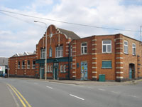
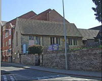
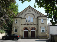
| Cross to the large car park opposite and follow the path west down to High Street. Turn right (north), and after 30 yards, on the right, is the Independent Wesleyan Chapel. The chapel opened on February 22nd 1900, and replaced a small chapel built in 1873 on this site. In 2014 the Church services were held in their Queen Street Schoolroom, behind the church. |
19
|
 |
Turn south in High Street and after 50 yards on the left is Lion Terrace, Nos. 52-58 High Street. Originally comprising 6 units, the 2 southernmost fell into disrepair and were demolished some time ago. The carving of a lion is set into the wall above Nos. 52/54. The terrace was built with the 'winnings' from a racehorse called 'The Lion'.
|
20
|
 |
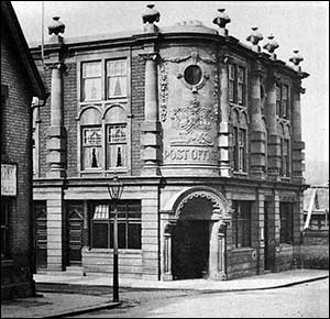
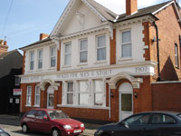
| Immediately opposite, on the right corner of College Street, is the Old Post Office. The building was erected in 1902 on land that was originally part of the "Cottage" Estate belonging to Boot Manufacturer John Cave. The first telephone exchange was located on the first floor and the western part of the building, in College Street, was used by the London City & Midland Bank. There was a fine, carved royal crest below the circular window on the corner, removed when the Midland Bank moved in. [now HSBC] |
21
|
 |
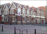
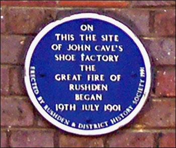
| On the opposite corner of College Street and High Street is the Rose & Crown PH and the immediately adjacent shops. These shops were originally surrounded by the enormous factory of John Cave but survived the great fire of 1901 that destroyed the factory and caused considerable damage to many nearby premises. Part of one wall of the factory still remains visible from College Street, abutting the west wall of the Rose & Crown. [look above the large gates] |
22
|
 |
75 yards along High Street, on the right, are shops erected after the great fire which is commemorated by a Blue Plaque above the former Evening Telegraph office at No.60.
Another 25 yards on the right is a Plaque commemorating the site of the former entrance to 'The Palace', Rushden's first cinema.
|
23
|
 |
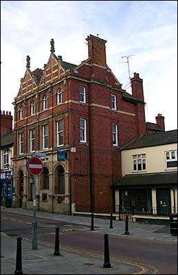
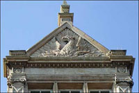
100 yards further on the right is the enormous building of The Nat West Bank [formerly the Northampton Union Bank]. Note the intricate stonework particularly on the door lintels, and the phoenix on the third floor gable.
|
24
|
 |
About 100 yards further, on the left, is a Blue Plaque commemorating where John Radburne conducted his business as a draper and lace dealer.
|
25
|
 |
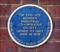
| A further 10 yards, but on the right, is a Blue Plaque commemorating the site of Rushden's first Co-operative Shop. |
26
|
 |
| At this end of High Street is St Mary's Church. To the left of the churchyard, and at the start of Newton Road is the Vestry Hall. Now much extended, it was originally used for Parish meetings and at one time as a school. |
27
|
 |
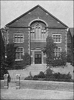
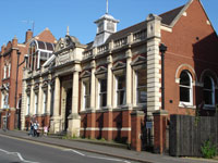
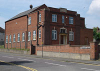
About 75 yards up Newton Road, on the right, is the Library. Andrew Carnegie, the Scottish-American millionaire donated £2,500 towards the construction of the Rushden Free Library which was opened on November 25th 1905 by the Marquis of Northampton. In 1995 the Library and the Council Buildings were refurbished and the two buildings were united by a new main entrance.
|
28
|
 |
Immediately beyond the Library, and on the corner of Park Road, are the Council Buildings. Opened in 1906, having been designed by Mr W B Madin, Surveyor to the Town Council, it was soon afterwards extended by the addition of a second floor in Newton Road.
|
29
|
 |
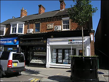
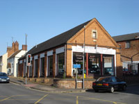
On the opposite corner of Park Road, the car spares shop was originally The British Women's Temperance Hall. It has been used by various organisations over the years, particularly as temporary accommodation for some of the chapels during their rebuilding or expansion programmes in the late 19th Century.
|
30
|
 |
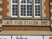
| 60 yards up Newton Road, the old fire station is the first old building visible on the left. Designed by Mr W B Madin, Surveyor to the Town Council, and opened in 1902 to house the hose-cart, a horse-drawn, manual fire engine and the wheeled escape ladder. Prior to this some of the equipment had been housed in part of Marriott's Farm buildings in High Street. There is a benchmark to the left of the station. |
31
|
 |
| Next to the Fire Station is the Athletic Club & Institute Opened in 1898. |
32
|
 |
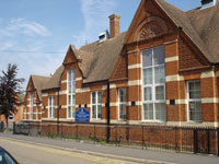
| Continue up Newton Road. After 100-150 yards, on the left, is Newton Road School. The school, with accommodation attached for the Headmaster and Caretaker, opened in 1894. H.E. Bates, Rushden's famous author, attended this school in his younger days. |
33
|
 |
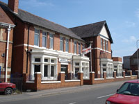
| Return down Newton Road and turn left into Grove Road (opposite the Athletic Club). After about 150 yards on the left is the former Unicorn PH, built 1907. [now a private house] |
34
|
 |
| Continue along Grove Road about 100 yards, on the corner of Roberts Street is the former factory of Robinson Bros. |
35
|
 |
| Next to the factory at No. 51 Grove Road, the birthplace in 1905 of H.E. Bates. |
36
|
 |
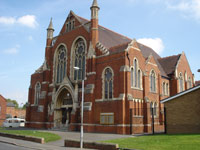
| After 25 yards back along Grove Road and turn left into Manton Road. Continue down and turn left into Park Road. On the left is the 'new' Baptist Church built in 1900. The Baptists moved from 'Top Meeting' to this new Church in Park Road on September 23rd 1901. |
37
|
 |
| On the opposite corner of Park Road and Crabb Street is the former factory of Cunnington Bros. |
38
|
 |
| Continue along Park Road. About 100 yards on the left is the old Methodist Chapel. H.E. Bates was the first boy to be baptised in the newer building on the right, after it opened in 1905.
Now the Heritage Chapel and Halls.
|
39
|
 |
| Return along Park Road and turn right opposite Manton Road, down Albion Place. On the right at the bottom of the alley on High Street South is the former factory of Wm Green, built in 1874. He built another factory in 1895 in Cromwell Road, and the company moved to Crown Park in 2013. |
40
|
 |
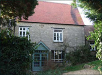
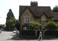
| Turn left along High Street South and after 150-200 yards fork left into Little Street. Almost immediately on the left is 'Greystones', formerly the Old Rectory. Originally a large, thatched cottage, from where a narrow walkway led to St. Mary's Church. In 1897 much work was done on this property when it was bought by Mr. Fred Knight, shoe manufacturer and first Captain of The Fire Brigade. Facing this are the remains of a memorial garden laid out in 1908. |
41
|
 |
| A few more yards, set back on the left, is the former Old Baptist Chapel 'Top Meeting'. The phases of this building can be better seen from the car park of No.72 Park Road.
|
42
|
 |
 Continue along Little Street for about 40 yards and on the left, above the trees can be seen The Old Baptist Assembly Rooms. The building is now private residences at No.72 Park Road. Continue along Little Street for about 40 yards and on the left, above the trees can be seen The Old Baptist Assembly Rooms. The building is now private residences at No.72 Park Road.
A little further along Park Road is a new development Knight's Court where Fred Knight had his factory (right).
|
43
|
 |
Return along Little Street and about 150 yards along High Street South, is the junction of Wymington Road. The stone house on the corner, 86 High Street South, is reputed to be Rushden's earliest Police Station. It contained a Lock-up Room and a stray animal pound was nearby.
|
44
|
 |
Continue north along High Street South. On the left, about 50 yards is the former South End School. Now the Full Gospel Church; it also has a shelter for the homeless.
|
45
|
 |
| Continue along High Street South to No.46 High Street South - the birthplace of Lt. Col. Bernard Vann VC, killed in action in 1918. His father was earlier headteacher at the old South End School.
|
46
|
 |
| Another 100 yards along High Street South, on the left is the former Waggon and Horses PH. [Now a restaurant]
|
47
|
 |
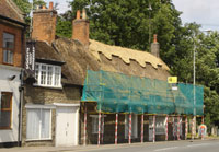
Next to this is the only thatched cottage left in Rushden, and still known as Florence Simpson's. Florence established her business here as a high-class ladies outfitter in 1922 when she took over the premises, previously her father's confectionery and tea rooms.
Another 50 yards along High Street South, on the left, is the entrance to Hall Park. |
48
|
 |
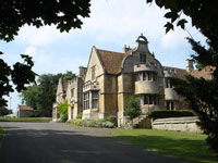
In Hall Park is Rushden Hall used in earlier times as a hunting lodge. After the last family to live there had left it was purchased by the Town Council for a public park in 1930. Following its de-requisition after WWII the Hall was allowed to fall into disrepair. The Rushden Amenities Society and others fought hard to stop the proposed demolition of the Hall in 1966-67.
Restoration has enabled it to be used as Council offices, public rooms and apartments.
It is also a popular venue for Weddings, exhibitions, and meetings. |
49
|
 |
Return to High Street South and turn left. About 100 yards on the right is The Wheatsheaf PH, rebuilt in 1888.
|
50
|
 |
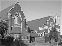
| Next to The Wheatsheaf is St Mary's Church. The height of the pierced crocketted spire, 162 feet, was re-measured in 1952-53 during major repairs to the stonework of the tower and spire. Other work included the hanging of two additional bells and re-siting of the existing six, thus bringing the peal to eight bells. Also installed was a new additional clock face. The interior has several ornate monuments and a particularly fine example of a strainer arch. |
51
|
 |
Opposite the Church on the former Village Green is The War Memorial. The memorial was constructed in 1920-21, and unveiled by Sir Arthur de Capell Brook, Bart JP, on Feast Sunday, September 25th 1921. Following WWII new plaques were added after fund raising by the Rotary Club, and these were dedicated on November 14th 1982.
|
52
|
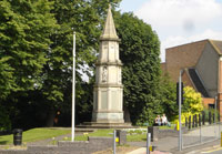 |
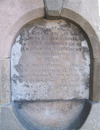
Outside the walls around the green on the lowest corner, was an old drinking water fountain - with a memorial to the Temperance movement.
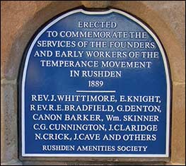
The memorial was refurbished in 2013 with this plaque.
|
53
|
 |
 On the left down the hill was the former factory and offices of William Claridge, established in 1860. [demolished November 2015] On the left down the hill was the former factory and offices of William Claridge, established in 1860. [demolished November 2015]
Skinners Hill was named after the family whose farm house stands at the top of the hill, facing the Wheatsheaf Inn. [now Mr. Chan, dentist] |
54
|
 |
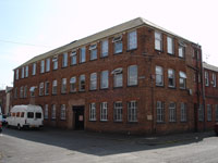
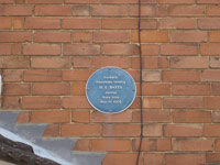
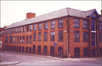
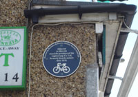
At the roundabout at the bottom of the hill, on the right-hand corner of Duck Street is an area well-known as 'The Lightstrung' - formerly a cycle business (recorded by a Blue Plaque on the last building in Church Street. A second Blue Plaque is to John White who made the building into his first factory in 1920), later a garage and car sales. The name Lightstrung immortalised on bus timetables as a major stop. The roundabout area is the site of the first Rushden Gas Works.
|
55
|
 |
|
Continuing in Wellingborough Road, cross Duck Street. On the opposite side of the road is the former Full Gospel Church. [now a private residence]
|
56
|
 |
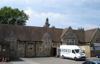
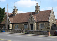
| Round the corner of Wellingborough Road and about 100 yards up the hill on the right are the Alms Houses, erected in 1883 by Mr and Mrs Sartoris of Rushden Hall, in memory of their son Frederick Maitland Sartoris who died aged 39 while working for the British Embassy in Turkey. A memorial may be seen on the south end of the row of four cottages, now converted into two. |
57
|
 |
|
Opposite the Alms Houses, on the corner of St Margaret's Avenue is The Masonic Hall, opened in 1930.
A short distance further on the right is a walkway back to the car park, where this walk began.
|
58
|
 |