Click here to return to the main site entry page
Click here to return to the previous page

Wellingborough Road
and House Name plaques
Colin Bryant Collection - Courtesy of Rushden Museum
c1950s - In 1883 four Almshouses were built to commemorate Frederick Maitland Sartoris, and two farm workers houses before extensions were done in the 1970s.

Marked places:
Almshouses
red
Adult School
yellow
Boot Factory
blue
Home Farm
Rushden Hall
pink
Village Green
green
Old Prims Chapel
magenta
Wheatsheaf Inn
cyan


The old village green, where a small chapel stood, is now the War Memorial and garden.

The start of Wellingborough Road from the Green c1888.

W'boro Road arch
Wellingborough Road - undated but for The King - 1902 or 1910/11?

1914
This fine postcard dated 1914 shows the area from the church. In the foreground and right is Church Street.

The little building fronting the road at the lowest point is "The Lightstrung", for many years where all buses stopped for all routes, and right of that is the house John White converted into his first factory.

In the distance is Glassbrook Road. Almost centre of picture can be seen some washing hanging in the gardens of Thrift Cottages, a row of seven almshouses. To the left of them, fronting the Wellingborough Road, are four more almshouses, the gift of Frederick Urban Sartoris, squire at Rushden Hall, in memory of his son.

1914 postcard - note the fields - built on in the 1930s

Claridge's factory now Stromag's No 29 was rebuilt in 1889
Rebuilt 1889 W C - no 29
William Claridge built his factory here and added a new warehouse in 1879 - part was rebuilt in 1889.

1887 Plan of Freehold Building Land to be sold
1887 plan

74 plots of Freehold Building Land with frontage to Wellingborough and four other streets to be sold by auction at the Wagon & Horses Inn on Tuesday 30th August 1887 at “three for four o’clock” in the afternoon.
Left of the map is "Victoria Street" but it was actually called Fitzwilliam Street. Across the middle is Moor Road with Lancaster Street and Dayton Street joining through to Wellingborough Road at the top of the map.


W'boro road shops
Miss Harris' drapery at no 144 - Reid's at 142 Wellingborough Road at corner of Dayton Street c1920

c1920s
c1920 - perhaps all on their way to the Mission Church?
They seem to be in their "Sunday best" clothes

Another early postcard

Bayes - no 78
Gladstone Terrace Plaque
Plaque West View
Bayes - no 78
Gladstone Terrace 1878 - nos 80-92
West View 1886 - nos 110 & 112

Gladstone Terrace Bayes Apparments
Gladstone Terrace 1878 - nos 80-92
78 refurbished as Bayes Appartments in 2009

Brookfield
Brookfield - 155 Wellingborough Road in 2009
originally designed by Herbert Adnit for Mr William Hewitt as two houses

The Mission Church - Wellingborough Road 2009

AED 1891 - no 173 Linden House
For more about

Wellingborough Road

see

1910 Valuations
and
Phillipson's Directory 1908

AED 1891 - 173 called Hazelhurst
175 Linden House built in 1895

c1905/10 by Sam Powell - The Co-op Store left at corner of Windmill Road

Collins' to the Oakley
c1905/10 adjoins the previous view - the shop is F Collins

warehouse
Mr Gates' warehouse - first building on the left

The building was taken over by Wildman & Bugby in 1942.

The office frontage in 2006
Wildman and Bugby
They moved out in 2015, and have since redeveloped the site, and named 'Wildman Court' housing.

Oakley Arms
204 & 202 South View 1892

built 1888 Lovell's Buildings 1893
(left) Lovell's Buildings 1893 which
adjoin the Oakley Cash Stores
of Tailby & Putnam
at 219 Wellingborough Road.
The houses were probably built by James Lovell, a shoe manufacturer, who died in 1898. His son John was the landlord when a fire at Mr Brightwell's occurred in 1904.

Around the corner from the stores in Irchester Road another terrace, called Lovell's Buildings, was built in 1894.

214 & 212 built in 1888
211 - 213 - 215 - 217

Westbourne Grove
Looking down from Irchester Road junction
with Westbourne Grove right.
Westbourne Grove - at the Oakley junction
Numbers are 224 - 260

The western part of the road was developed from 1897.

262 Westhill 278 built in 1989
262 Westhill
278 built in 1989 (infill)

276 Glenhurst House also on the gate posts
Glenhurst House

247 Ivanhoe
267 Dean House
271 Rokeby House
247 Ivanhoe
267 Dean House
271 Rokeby House

Rushden Echo 30th September 1921, transcribed by Susan Manton

For Sale by Private Treaty - 249 Welingborough Road

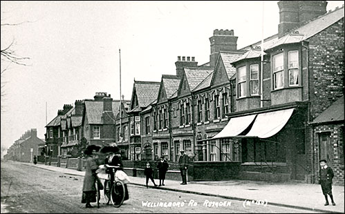
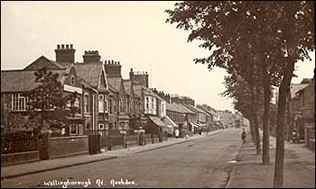
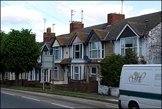
The newly erected Semi-detached Villa Residence known as “Rosslyn” and situate 249 Wellingborough Road, Rushden, of brick, pebbledash, and slate erection now in the occupation of Mr. Joseph Ladds, the owner, and containing drawing and dining rooms, kitchen, scullery, 3 bedrooms, bath room, box room, and the usual domestic offices, with motor garage at the rear. There is a side entrance from Gordon Road.

Possession may be obtained on 10th October next. Permit to view and further particulars from John S. Mason, Auctioneers and Estate Agent 30, High Street, Rushden.


from St Peter's Avenue
Wellingborough Road, looking towards the Oakley from St Peter's Avenue, c1970s.
It was marked by Arthur George to be trimmed for a postcard.
The notice board (left) reads "Rushden U D C Sewage Treatment Works"
This open ground (left) is now built on - St Nicholas Way & The Paddocks - with
Heatherbreea (see below) at the outskirts of town.

postcard of Heatherbreea reverse
Postcard of 'Heatherbreea' - John Clark used it as a Xmas greeting but unused so no date - c1905?
Land adjoining was a sand pit, and here John Clark had his brickworks.
The grounds of the house have been built on - see Heatherbreea Gardens

Rushden Brick & Tile Co location, shown on an Ordnance Survey map of 1927
Rushden Brickworks and tramway, shown on a map of 1927
John Clark lived at Heatherbreea House

Click here to return to the main index of features
Click here to return to the History index
Click here to e-mail us