Click here to return to the main site entry page
Click here to return to the previous page

The Sidney Brook
culverting of the Brook in 1969 - photographs by A J George

Duck Street and The Brook - by Arthur Mantle

Sale May 11th 1882. This photocopy of the map is all we have:
1882 plan
The course of the Sidney Brook is marked in black on the map.

The Argus, 25th August 1916, transcribed by Kay Collins

Rushden’s “Old Cross Roads”

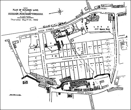
“Mr. Cobbler,—As you well know, from the bottom of Church-street to ‘Sanders’ Lodge’ is called the ‘Wellingborough-road.’ The spinney along the Irchester-road (next to where Mr. Chettle lives) is properly ‘Higham-lane Spinney,’ and the road from there to the Oakley Inn ‘Higham Ferrers-lane.’ From the Oakley Inn to the Rushden Turnpike (north end) is Washbrook-road. The old name for ‘Sanders’ Lodge’ is ‘Hill’s Hovels.’

“From the latter place, under the Midland Railway, over ‘Skew Brig’ and ‘The Brook’ to Higham Ferrers is the Wellingborough-Kimbolton Turnpike. From Mr. John Mason’s down past North-end Schools, to the foot of old Bancroft Hill is ‘Hayway,’ and has been so named for at least 90 years. The roads above mentioned (except to Higham and to Knuston) encircled the old ‘Moors,’ which has retained that name more than 400 years. I suppose the Oakley Hunt met there 60 or 70 years (the last time perhaps about 20 or 25 years ago).

“The roads also surround the Recreation Ground. This is interest to me, as the parish or town purchased what ought to have belonged to them, as it is the very land which was left towards the lighting of the Parish Church 380 years ago. Why was it lost? All who went to a place of worship in those days went to the Parish Church, the only building. There were no chapels then, so I say the ground was left entirely to the town for the Church. I repeat the name of the brook which runs through the Recreation Ground is ‘Sidney Brook’ (I do not know how it got that name), and those old willows are something to be proud of, especially being about the only spot where one can find a little shade on a hot, bright summer day in the Spencer Park.

“It matters little, I suppose, what a ‘brook,’ ‘road,’ or ‘wood’ is called but let us keep the names, at anyrate those which have been handed down a hundred years or more. The wood close by has always been called ‘The Moors.’ It is a pity the Recreation Ground is not central. I should like to see one for the young people up Southende.

J Enos Smith
22 Church-street


Extracts from the note books of J E Smith NRO Ref: 285P/272-301

The Rushden Red Spring - I was very pleased your correspondent drew my attention to the source of the Rushden Brook. The tenant of the allotment where the Spring rises not only gave me permission to see it, but he also explained it. It is in the north end of the “Oak-pits” in the valley about 25 yards from the hedge of the shoeing field. The sediment at the bottom of the spring and for several yards down to brook is of a reddish colour, and is certainly different to any other I have seen. I understand that it is medicinal, and a very good lotion for weak eyes. Many people have used the water as far back as 1868. The brook continues southward, but the water is quite ordinary above the spring.

We have read about Redwell at Wellingborough, and the healing properties of the water, and of King Charles staying there to drink of the same.

Why not have our “Red Spring” listed and analysed, and if valuable advertise it, and make Rushden equal to Bath, Buxton, Leamington, and other places?

Since this war we have found out the real value of many springs. Mr Smith the chemist, a gentleman very interested in “old” Rushden has kindly promised to analyse it. J Enos Smith (Appeared in “Argus” Friday August 11th 1916)

Sep 12 1927 “The Brook” Bedford Road, opposite Boot Factory and Co-op Park – I found covered in this day. Men at dinner on bank beside road, it will be much better now.

Oct 18 1927 I went up the Bedford road as far as Co-op Park to day & the edge stone of new path was being fixed just opposite Mr Tarry’s Boot factory, the road and path straightened, the path now practically over the brook, and the ditch opposite-side of road leading up to the 5 or 6 cottages, from the Co-op Park yesterday. [The '8 houses'?]


Rushden Echo, 7th November 1924, transcribed by Kay Collins

The Brook in front of the South-End Schools has now been covered in by brick culverting. The extra area to be allotted to the school playground and to the public footpath will be a very welcome improvement.


Click here to return to the main index of features
Click here to return to the History index
Click here to e-mail us