Click here to return to the main site entry page
Click here to return to the previous page

Laughton's Farm
or Lawton's Farm

Extracts from Memories of the 1890s - Approaching Rushden from Higham Ferrers, 50 years ago, one passed a few cottages, known as "The Rookery," before coming to Mason's Farm, which was situated where the Victoria Hotel now stands. Then there was Denton's Farm, the original farmhouse having stood until recently. Laughton's Farm was where Queen-street now runs, and finally there was Smith's Farm standing where Griffith-street now is. These farm properties stretched a long way towards the eastern end of the village and, with certain exceptions, adjoined. Not far from Laughton's Farm were limestone pits. There are still traces of these pits which were afterwards used as rubbish dumps, so that there are now houses in Queen-street which have been built upon innumerable old saucepans and pots and pans.
All the property and buildings from Queen-street to Newton-road now stand on what was Laughton's Farm, which adjoined the Rectory glebe land. A part of the Rock Estate on the Newton-road side included a large field known as 'Nipping Dale.' This started at a point somewhere near to where the Fire Station now stands, and here, on Saturday afternoons, the lads of the village played Rugger.

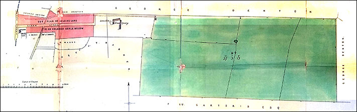
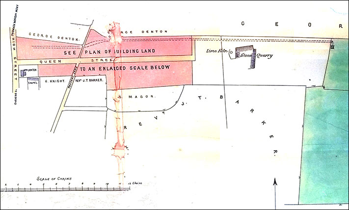
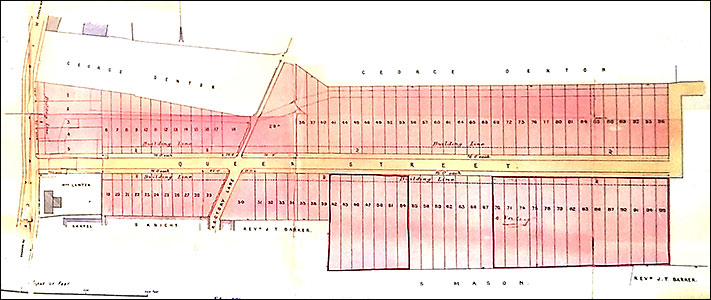
Thomas Lawton died early in 1886, aged 74, and the land was sold. This land became a building site for Queen-street and the Rock Estate.

This plan shows the portion of George Denton's land closest to High Street adjoined on the north side, and Rev J T Barker was close on the south side, beyond Rectory Road.

the plan
Plan drawn in May 1886 by Edward Sharman of Wellingborough showing the land of Thomas Lawton deceased.

The area colour pink designated building land fronting the High Street, and behind
the white area with a stone pit and lime kiln with his pasture land beyond.

area
The building area with Mrs Lawton's house marked closest to High Street and next to the old Wesleyan Chapel.
The lime kiln and stone pit marked beyond. The scale is shown in chains.
plots
The layout of the building plots, with High Street (left) and Rectory Road.
The large plot on the east side of Rectory Road is where the Salvation Army Barracks were erected in 1888.
The piece of land belonging to George Denton, shown between High Street and Rectory Road, was rented by
Jonathan Seckington, where he established his nursery and orchard, and opened a shop at the High Street end.

Rushden Echo, 9th October 1908, transcribed by Kay Collins

Five plots of freehold building land in Queen-street, with frontage of 75ft., and containing 830 square yards, or thereabouts, together with the stable and buildings thereon, were withdrawn at £100.


Click here to return to the main index of features
Click here to return to the Land, Property & Tax index
Click here to e-mail us