|
|
Source: RUSHDEN A Duchy of Lancaster Village by David Hall & Ruth Harding
 |
|
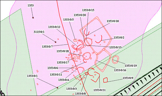
Site of a prehistoric settlement near Rushden.
Copyright Northamptonshire County Council |
Rushden is a large parish covering 3,775 acres and lying on the slopes of the Nene Valley. The archaeological record shows that Northamptonshire was occupied by early man long before historical times. Two bronze axes were found in Rushden and recorded in 1838 and 1953 but unfortunately both are now lost. The most obvious evidence of Bronze Age settlements were the barrows where wealthy tribesmen were buried. Rushden had a group of three barrows in the meadows near Ditchford Mill. The Iron Age lasted from about 700 BC until 50 AD and Rushden has two Iron Age sites, one on the corner of Melloway Road and Irchester Road (at the site of the Welcome Inn) and one near Avenue Road.
Roman settlements have been found near Bedford Road, Avenue Road and Newton Road but were probably just small agricultural settlements as there has been no evidence of any larger. Some Roman finds have been made in Robinson Road, Quorn Road, Wellingborough Road and Fitzwilliam Street.
There have been no Saxon finds made in Rushden but later records reflect its importance, equivalent to the settlements of Higham, Irchester and Raunds. The above towns together with Rushden and Wollaston represent the ancient centre known as the Higham Ferrers Hundred. The word hundred was used to identify a group of parishes which added up to a nominal 100 hides which was a unit of taxation imposed on an estate or manor.
There is evidence of Danish settlements in Rushden where there was a South End and a North End which was associated with a manor called Scanthorpe, which is a Norse name, supposedly situated in what is now Duck Street.
Just before the Norman conquest Rushden was a small nucleated village with two manor houses, a church, a mill on the river and open fields all around.
In the Domesday book in 1086, twenty years after the conquest and under the name of William Peveral details are entered for Higham Ferrers followed by the text for Rushden:-
| to this manor belong these members: Risdene (Rushden) with 6 hides. Land for 12 ploughs 19 sokemen have them there. (There is) a mill at 10 shillings and meadow 30 acres. |
It continues:-
|
Value of the whole manor with dependencies, £10 when acquired; now £18. Gitda held it with full jurisdiction. The sokemen of Rushden, lrchester and Raunds were Burreds men; for this reason Bishop Geoffrey claims their homage.
|
Lands belonging to William Peverel in Rushden constituted 6 hides, 0 virgates and 12½ ploughlands. In 1066 the estate was called the Soke of Higham and belonged to Gitda (Gytha) who was the wife of Earl Ralph of Hereford nephew of Edward the Confessor.
|
|
|
|