|
||||||||||||||||||||||||||||||||||||||||||||||||||||||||||||||||||||||||||||||||||||||||||||||||||||||||||||||||||||||||||||||||||||||||||||||||||||||||||||||||||||||||||||||||||||||||||||||||||||||||||||||||||||||||||||||||||
| Extracted from “Rushden A Duchy of Lancaster Village” by David Hall and Ruth Harding 1984, with kind permission |
||||||||||||||||||||||||||||||||||||||||||||||||||||||||||||||||||||||||||||||||||||||||||||||||||||||||||||||||||||||||||||||||||||||||||||||||||||||||||||||||||||||||||||||||||||||||||||||||||||||||||||||||||||||||||||||||||
|
Manors of Rushden
|
||||||||||||||||||||||||||||||||||||||||||||||||||||||||||||||||||||||||||||||||||||||||||||||||||||||||||||||||||||||||||||||||||||||||||||||||||||||||||||||||||||||||||||||||||||||||||||||||||||||||||||||||||||||||||||||||||
|
Estates were organised as manors by the Saxons and Normans. In simple cases a manor would be coextensive with a parish, and consist of a village and its fields. Within a manor everyone held land from the lord, even the freeholders paid nominal dues and acknowledged the lord at his local court. Quite commonly there was more than one manor in a village, and this is the case with Rushden where there were two. The Domesday survey 1086 Rushden is first mentioned in the famous survey made by William the Conqueror in 1086, the record of which became known as Domesday Book. The Survey was made for taxation purposes, and is the oldest fiscal assessment of any European country. It records the names of the owners of lands in 1086, the amount of land held, and other details about undertenants and the values of meadows, woods, and mills. Often the name of the owner in 1066 is also given. The entry for Rushden is reproduced by Kerr.1 Under the name of William Peverel, the 35th landowner in the Northamptonshire section, details are entered for Higham Ferrers. The text then goes on:
The entry continues with land in Chelveston and other villages, all belonging to Higham (Table 2), and finishes Value of the whole manor with dependencies, £10 when acquired; now £18. Gitda held it with full jurisdiction. The sokemen of Rushden, Irchester and Raunds were Burreds men; for this reason Bishop Geoffrey claims their homage.2 The lands described comprise the whole of the parishes of Higham, Chelveston cum Caldecott, most of Raunds and Rushden, about half of TABLE 2 Domesday Returns
All the above belonged to Gitda (Gytha) in 1066. Peverel lands in other parishes, not originally Gitda's:
Rushden lands assessed with Bedfordshire Bishop of Coutances: half a hide and half a ploughland held by Aelfric, Burgred's man. William Peverel: one virgate and land for 2 oxen held by Saemer the priest, Countess. Gytha's'man Knuston and Irchester, and smaller parts of the other places. The estate was called the Soke of Higham and, in 1066, belonged to Gitda (or Gytha), who was the wife of Earl Ralph of Hereford, nephew of Edward the Confessor. Most of the other lands acquired by William Peverel in Northamptonshire had also been Gitda's. William Peverel held estates in many other counties besides Northamptonshire. In this county he possessed 38 manors as well as the Higham complex, and 32 houses in Northampton itself. His main estate was in Nottinghamshire, where he had a castle (Peverel or Peak castle). He was appointed constable of the king's new castle in Nottingham.3 Land was measured in hides for taxation purposes. Hides were divided into four parts called virgates. A virgate, in later centuries, was a peasant holding, sufficient to support a family, and was usually in the range of 20-40 acres. However, the Domesday hide consisted not of 4 virgates but 12 (10 in some parts of the county). The Domesday virgate, therefore, being a quarter of a Domesday hide, was equivalent to 3 (or 2½) peasant holdings. It is thus necessary to distinguish clearly between the large virgate of Domesday, and the small virgate of later times. Even more problems arise on the interpretation of the second class of Domesday statistics, the 'land for ploughs' or ploughlands, of which there were 12 for Rushden. When studied over the whole county it can be shown that they do not represent, as might be expected, a measurement of the arable suitable for ploughing, but are an earlier assessment for taxation.4 Thus the Rushden 6 hides indicate a rateable value for 1086 and the 12 ploughlands represent what it was previously. It will be shown later that these ploughlands do indeed relate to hides because there were 48½ peasant holdings accounted for in 14th-century sources, that is 12 hides each of 4 holdings (or small virgates). Evidence will be given to show that at Rushden a peasant holding was 40 acres. The Domesday arable was the number of peasant holdings multiplied by their acreage, which equals 1,920 acres at this manor (48 x 40 acres). Domesday Book records all kinds of tenure that belonged to various manors, from slaves to freemen. At the Rushden Peverel manor there was only one type mentioned, the sokemen. They virtually had the status of freemen, and were certainly better off than the more common villeins (bondmen) of other manors, who were tied to the land, and who could not leave the manor without the lord's permission. Sokemen had to pay some rent and perform work-service on the lord's home farm. They seem to be descendants of Danish settlers. The mill mentioned at Domesday does not occur in records after 1327, but its site can be worked out from a survey made in 1591 (see below Chapter 7). It stood at the north-east corner of the parish on the river. By the 14th century Rushden shared a watermill with Irchester at Ditchford. The meadow referred to in 1086 would have been held privately by the lord. In contrast the rest of the meadows were allotted in strips for cutting hay, and then were thrown open to the village animals as common grazing land. The value of the Higham manor with its dependencies had increased between 1066 and 1086. Round showed that in Northamptonshire the increase is better interpreted as a recovery of value to what it had been before 1065. In this year the Anglo-Saxon Chronicle records that a rebel army led by Morcar attacked Northampton. The route taken by the army was probably from Peterborough up the Nene valley; it is along here that here are many manors with values greatly increased in 1086. The inference is that in 1066 some of the manors, including Rushden (which had been ravaged by the army), were still devalued.5 The final point of the Domesday entry for Rushden Peverel manor that requires comment is the claim for homage. 'Bishop Geoffrey', the Bishop of Coutances, acquired an estate that formerly belonged to the Saxon Burred (alias Burgret), and which spread into Bedfordshire and Buckinghamshire as well as Northamptonshire. In preconquest times freemen and sokemen could commend themselves to a lord of their own choice in return for his protection and favour; for this they did homage, that is they presented themselves at a baronial court. The Peverel sokemen had paid homage to Burred, and so the Bishop continued to claim it also. Ancient Demesne of the Crown There was another manor at Rushden in 1086, but it is not easy to recognise it from the Domesday entries. Ancient Demesne of the Crown was land held by the king before the Conquest. The main local crown estate was centred on Finedon which, in 1066, was held by Queen Edith, Edward the Confessor's widow. The whole estate, called the Soke of Finedon, stretched over several hundreds, there being 10½ hides in Higham Hundred, but none of the places in which the land lay is specified.6 However, an enquiry held in 1318 states that in Rushden there were 10½ virgates: each virgate contained 40 acres, which amounted to 5¼ hides of land.7 The information clearly establishes the existence of another manor, but the assessment in hides and virgates requires an explanation since it is different from the Peverel manor. By the 13th century the use of the word 'virgate' (sometimes called the small virgate to distinguish it from the large virgate of Domesday as explained above) invariably means a peasant holding of 20-30 acres depending on the parish. The Rushden virgates are larger at 40 acres, that is twice the usual size. This size is reflected in later documents in that some of the holdings of the manor are let out in half virgates (see the 1591 survey, below). Thus the hidage is calculated at two 40 acre virgates per hide, which is equivalent to four half-virgates of 20 acres, that is four 20-acre units to the hide. The crown demesne manor was assessed at 5¼ hides in 1318 and 1086, but in contrast to the Peverel manor, which had 12 small virgates or peasant holdings to the hide, this manor had only 4. In other words the demesne manor has as hides what elsewhere would be classed as ploughlands. Hart has shown that crown demesne in other parts of the county had a different type of Domesday assessment from secular estates.8 He concluded that the Domesday ploughland entries for royal demesne represented their pre-Danish hidation. We would go further, and suggest that for some demesne manors, the actual hidation figure is the original unchanged assessment. This seems to be the case with the Rushden royal demesne manor. Rushden lands in Bedfordshire It is difficult to follow the descent of the Rushden lands said to be in Bedfordshire in 1086 (Table 2). They presumably became amalgamated with the other Peverel lands. The virgate belonging to Saemar the priest may be that given by Peverel to Lenton Priory, and if so proves that there was a priest and church in Rushden at this date. However the 1 virgate of Domesday would be expected to appear in later centuries as 3 small virgates, which is not the case. A further interpretation of the Domesday assessment is given in Chapter 4, using evidence from the open-field holdings. Location of manor houses The above analysis of 11th-century fiscal returns has shown that there were two manors in Rushden, and probably therefore, two manor houses. The documents tell us nothing about the sites of the buildings, and previous literature on the subject, influenced by later events, asserts that the manor house of Rushden was not in the village, but at Higham Park.
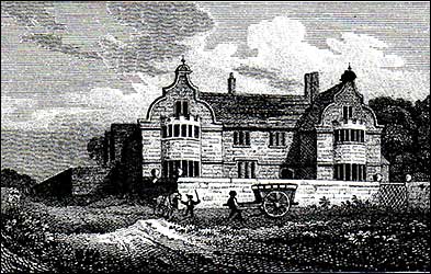
Yet in 1086 there was no Park, and the manor house would be in the village centre, and probably near the church. The sequence of events would be the other way round, with the manor house first, and the lord offering a site for a church conveniently near his dwelling. Rushden Hall fits this description: its imposing site and spacious grounds, even today indicate that it was the principal building.
The county historian, Bridges, who compiled his notes in c.1720, referred to the Hall by quoting Norden:9
By that time the Hall no longer owned the Rushden manorial lands, but in the 11th century it would have done so. There can be little doubt that in 1086 the Hall was William Peverel's Rushden manor-house. The crown manor-house site requires more detective work for identification, just as the existence of a manor in 1086 was not obvious. There is no documentary evidence to state that there ever was a manorial building in Rushden for this manor. There was, however, another substantial building called Scanthorpe. In c. 1720 Bridges notes:
It is unusual for Bridges to name and mention a building other than the church and manor house. Scanthorpe can be traced back to 1407 in the form scantroplane.11 In 1444 a fine was made upon Henry atte Hall for placing a fence in the common street next to scanthroplane.12
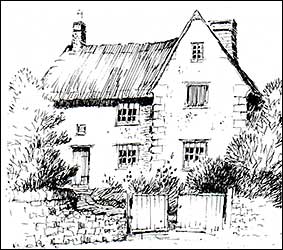
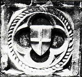
This building was perhaps the manor house for the 1066 crown manor. J. Enos Smith decided that Bridges' description fitted 'Mr. Bird's house'.13 This was a large stone house, on the site of the present Duck Street car park (Fig. 3), which was knocked down in 1937. A painting of it survives (Plate 4a). Cole notes in 1838 'there are marks of antiquity in carved stones enriched with quatrefoil etc. on the gable end of a barn', and also 'there is a carved stone now used as a horse block'. Another description in 1853 states 'an old house here has two enormous carved stone panels in its front; one of the arms of St. George within a quatrefoil, and another of two heads in hats'.14 One of these stones survives (Plate 4b) and seems to be late medieval. It is clear from the descriptions, the drawing and the one architectural fragment, that Scanthorpe was a substantial building, of manorial type. Duck Street was probably the scanthorpe lane of the 15th century; both roads run north-south, and one name supplants the other.
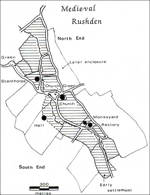
The fragmentary evidence suggests that each manor house controlled its own part of the village. There is no description of the Scanthorpe lands, but Peverel land subject to bondhold tenure (held by bondmen, see Chapter 3) can be identified from later records because tithes were due to the rector. From an 18th-century description it is clear that the homesteads all lay in the South End, that is around the Hall (Chapter 6).15 The arable land belonging to the manors was intermixed, as explained in Chapter 4. Descent of the manors The ownership of the Rushden manors from 1066 to 1400 is summarised in Table 3. It can be seen that from the Peverels the estate went to the Ferrers family (who were earls of Derby), and then passed to the earls and dukes of Lancaster, and so to the crown. This descent is common to all the Peverel lands in the Higham Hundred, and is detailed by Kerr16 and the Victoria County History.17 An outline of manorial descent will be given here, emphasising relevant items omitted or not stressed by earlier authors. In the first decade of the 12th century William Peverel founded the Cluniac monastery of Lenton, near Nottingham. He also founded St. James Abbey, a house of Augustinian Canons, on the west side of Northampton (the present 'Jimmy's End'). A later document (see below) refers to William Peverel in connection with Higham Park where he created a deer park for hunting. William Peverel died in 1114, and was succeeded by his son of the same name, who was a supporter of King Stephen during the civil wars of 1135-1143. His lands were forfeited in 1141, but restored in 1143. Henry Plantagenet, later Henry II, made a prospective grant of the Higham manor and its dependencies to one of his supporters, Ranulf, Earl of Chester. Some months later the Earl died, poisoned, it was claimed, by Peverel. With the accession of Henry to the throne in 1155, William Peverel II went into hiding as a monk in one of his own monasteries, to escape punishment. He then disappeared from history, possibly having been murdered. William Peverel's heir was a daughter, Margaret, who married Robert de Ferrers, second Earl of Derby. Henry II had seized the Higham lands and granted them out to various people during his life time. From 1157 until his death in 1159, they were in the hands of Robert de Ferrers. On his accession in 1189 Richard I granted the Higham estate (always including Rushden) to his brother John. In 1199, as soon as he became King, John sold the estate to his friend William de Ferrers, fourth Earl of Derby, grandson of the second earl already mentioned, and the accepted heir to the Peverel lands through his grandmother. The price was 2,000 marks (£1,333 6s 8d), and William had to surrender any claim to other Peverel lands outside of the Higham Ferrers Hundred. William de Ferrers seems to have been fifth in line of descent from Henry de Ferieres. He came over with William the Conqueror in 1066. The estates granted to him were mainly in Berkshire, Leicestershire and Derbyshire. His French estates descended to his eldest son, and the English lordships were given to Robert, a younger son, who was later made first Earl of Derby by King Stephen. Robert died in 1139 and was succeeded by another Robert, the second Earl, who married Margaret, William Peverel's heir. Robert's son and heir was William, who was probably the same William, Earl of Ferrers who died on a crusade in 1190. It was because of the association with this family that Higham became 'Higham Ferrers', to distinguish it from Cold Higham. At this time we get more information about the two Rushden manors. Kerr speculated that they merged in 1189 or 1199, when Richard I gave the Peverel lands to John, or when John gave them to William de Ferrers. Two pieces of 12th-century evidence are more precise. The grant of Higham and its dependent manors in 1199 mentions the Park,18 and the royal accounts for that year, referring to Ferrers' payment, state 'the park [which] his [John's] greatgrandfather' gave in exchange to William Peverel's ancestor', in other words Henry I gave the first William Peverel some crown land, which can therefore be dated to between 1100-1114 (being the dates of Henry I's accession and William Peverel's death). If land was transferred it is likely that all the crown lands in the hundred were given. This is confirmed by an early 12th-century survey of the whole country. The survey lists all the manors in the Higham Hundred, including outlying Peverel ones in Bozeat and Hargrave, and then merely states that in 'the demesne of William Peverel' there are 33 hides and 2½ virgates.19 The 'demesne' was the original nucleus of the estate thai was Gitda's in 1066. Reference to Table 2 shows that her manors add up to 24 hides 3½ virgates, which is too little. However, if the 10½ hides of the crown estate attached to Finedon are included, then the total is 35 hides 1½ virgates. The same survey mentions estates in Finedon parish itself, but does not refer to the Soke of Finedon any more, implying that outlying lands were assessed with their own parishes, and that the Soke of Finedon no longer existed. Proof that William Peverel obtained the Crown demesne manor before his death in 1114 comes from the tithe records. A 14th-century rental and survey (see later) shows that the 10½ virgates of the Soke of Finedon formed part of the 45½ virgates of the sokage land the tithe of which was given (impropriated) to Lenton Priory; the bondhold land remained attached, in respect of tithes, to Rushden church. Therefore William must have possessed this land before 1114, and sometime after 1086, probably as part of the exchange with Henry I. To return to the Ferrers family. William the fourth Earl died in 1247 and was succeeded by his son William, fifth Earl who was a favourite in the court of Henry III. In 1248 he obtained a royal grant of free warren (the right to hunt) in his manors of 'Hecham, Raunds, Rissendene, Knoston, Yrincestre, Stanewigg, Chelvestone, Ringstede, and elsewhere'. The fifth Earl of Derby died in 1254 and was succeeded by his son Robert, who joined the baronial party against Henry III in the troubles of that reign. He was captured in 1264 and his lands seized by the king. Although pardoned he rebelled again, and his lands were granted to Edmund, second son of Henry III, created Earl of Lancaster in 1267. Robert was allowed to redeem his estates if he paid Edmund the value of his lands for 7 years (7 years' rent receipts). The King imprisoned him until he agreed to pay £50,000; Robert and his son John tried to raise the money, but failed in the time allotted. Robert tried to sue Edmund saying that the 7 years' value had frequently been offered; but the court of the King's Bench found in favour of Edmund. Robert died in 1274, and so the first Earl of Lancaster acquired the Higham manors by rather devious means. Edmund died in 1296. His father and brother had given him many estates, and these were all surveyed in 1298, giving the first detailed account of the separate manors. The Higham estate was split into four administrative centres one of which was styled 'The Park with Rissenden'. By this date the lodge house of the Park had become the residence of the Rushden bailiff, and the manor houses in the village were of less importance, having become small private 'manors'. Thomas, Earl of Lancaster and Leicester, son of Edmund, came of age in 1298 and took charge of his lands. During the reign of Edward II he was one of the lords who opposed the King, and was involved in the murder of Gaveston. For this the king imprisoned Lancaster, and put him to death after an irregular trial in 1322. On the accession of Edward III, Henry, brother and heir to Thomas, was created Duke of Lancaster, and received all the Lancaster lands. His son Henry acquired the property upon his father's death in 1345, although he was not made Duke of Lancaster until 1351. He died of the plague in 1361, and the lands were divided between his daughters Matilda and Blanche. Matilda died in 1369 and so the whole inheritance came to John of Gaunt, Edward Ill's younger son, who had married Blanche. John of Gaunt was created Duke of Lancaster in 1362. After his death. in 1399, he was succeeded by his son Henry of Bolingbroke, who had been banished from the country by his cousin Richard II. He returned to England; Richard was forced to abdicate, and parliament admitted Henry's claim to the throne as Henry IV. Rushden, as part of the Duchy of Lancaster, was thus merged with the Crown, having descended from the Domesday holders, through the Ferrers family, finally resting with a large royal estate. Thereafter the descent of the manor lies with the Crown, and interest shifts to the lessees. A rental of 1313-1314 describes the demesne farm in hand, managed by the earl of Lancaster's resident agent (reeve) from the Park.20 Such an arrangement was probably in operation earlier under the earls of Derby. However, account rolls of the later 14th-century show that the 'farm' of the manor was leased out; the lessee paid a sum for the demesne, and managed the other affairs of the Park and manor as well. John Bedell was reeve of the Park in 1356;21 he was succeeded by Hugh Lyne, and Edmund Barnard held the farm of Rushden with the Park from 1365 to 1375.22 The rent was 20 marks per annum (£13 6s 8d), and Edmund received some of the sokemen's commuted rents. Thereafter the manor was always rented, Thomas Richard was lessee from 1401 to 1420.23 In 143024 and 144925 the lease is said to be in the hands of 'Thomas Richard and others', which makes Thomas rather old. More probably, the accountant was copying earlier rolls each year, and the lease belonged to the heirs of Thomas Richard. Sometimes the Park was leased separately from the demesne, as in 1449, when it was held by John Sayer and Thomas Tresham.26 Robert Pemberton possessed the demesne lease during 1461-1481. 27 The account rolls after 1481 describe the farm of the 'manor and Park' as being in the hands of several freeholders.28 Later surveys show that nearly all the 'farm' remained with the Pembertons. The last time the demesne can be identified is in 1610, after which it became dispersed and lost amongst the other tenancies. The Hall reverted to the Duchy and was in the hands of the Ekins family from about 1641 until 1724, when it was purchased by Jeremy Sambrooke. Local yeoman farmers were the occupiers until 1812, and there were several owners until the Sartoris family took residence in 1843. Freeholders The Victoria County History lists various early freeholders and seeks to associate them with holdings descending to the 17th-century Page family, and assumes that the small estates became merged with the Hall. It is much more probable that they were always independent, and not merged. Freeholders are listed in surveys of the mid-14th century, 1591, 1610, 1649, and at the enclosure in 1778. The earliest freehold recorded was 1 virgate 8 acres held by Warin le Falconer in 1204. His heirs were two daughters Sara and Wymare. Henry de Billing married Wymare, and Sara sold her share to them in 1222 (then stated to be half of 3 virgates). This land was assessed at 1/6 of a knight's fee in 1242 (a knight's fee was a rent sufficient to pay for the upkeep of a knight, and was an assessment that replaced hides). In 1284 it was held by the heirs of Henry de Billing as ¼ of a knight's fee. A survey of the property of Edmund Earl of Lancaster in 1298 assigns 1/5 fee to one Richard (name illegible), and a 14th-century rental and survey records Richard Fouke as having the same estate. This property is almost certainly Rushden Hall which had been made a freehold when the manorial centre moved to the Park. TABLE 4
It seems from the above that the 1 virgate possessed by Warin le Falconer was a large virgate, still using the Domesday assessment method. This would appear later as 3 small virgates, and Warin's two daughters are said to share 3 in 1222. The estate is then described as fractions of a knight's fee: comparison with other villages shows that a knight's fee was approximately equal to 24-28 small virgates, so that 1/6 to ¼ of a fee would be 4-7 small virgates. The Hall in 1610 had 100 acres of land, equivalent to 5 peasant-holdings of 20 acres each, which was the normal rating. These values are consistent with the 13th-century freeholds above all being the Hall. From Richard Fouke the freehold Hall manor-house came to the family of Bedell; John Bedell was described as a freeholder in 1429.29 William Salt lived at the Hall in the mid-15th century; he replaced John Bedell as the major freeholder in the Hundred court roll of 1461,30 and occurs several times in Rushden court rolls. The Pemberton family acquired the Hall freehold and lived there during the 16th century, and until 1641. The Hall then became the property of the Duchy again, and was leased out to the Ekins family and others, as explained above. Other freeholds mentioned are one virgate of Warin son of Nicholas in 1219, and two virgates acquired in 1290 by John de Brabason from the heirs of Henry le Savage.31 William Brabason held 1/40 of a knight's fee which he had acquired from Ralf de Punchardon; in 1428 this land was the property of John Bassett. A 14th-century rental and survey records all the freeholders, but unfortunately this part of the document is damaged. Not less than 21 holdings are itemised, most of them small. The small size of the freeholds is why only the Hall gets a mention (not by name) in the 1298 inquisition, all the others being of too little value to interest the assessors. Likewise the small freeholders do not stand out in the Poll Tax list of 1381, where only four people paid more than the standard 4d (Table 9). If the later records only had survived it might have been interpreted that the freeholders had arisen in the 15th century, during the breakdown of the feudal system. However, the Rushden records show that freeholders had been there since at least the 13th century. In all probability they represent preconquest Saxon and Danish freeholders who had resisted being absorbed into the manorial system. In summary we see that Rushden had two manorial centres in the 11th century, and that they descended to the Duchy of Lancaster in the 13th century. The main manor-house in the village, the Hall, was no longer needed when the administrative centre was moved to the Lodge in the deer park. It was sold as a freehold, paying a nominal sum to the Duchy. The occupants still feature in the records because they frequently leased Duchy property.
|
||||||||||||||||||||||||||||||||||||||||||||||||||||||||||||||||||||||||||||||||||||||||||||||||||||||||||||||||||||||||||||||||||||||||||||||||||||||||||||||||||||||||||||||||||||||||||||||||||||||||||||||||||||||||||||||||||
|
|
||||||||||||||||||||||||||||||||||||||||||||||||||||||||||||||||||||||||||||||||||||||||||||||||||||||||||||||||||||||||||||||||||||||||||||||||||||||||||||||||||||||||||||||||||||||||||||||||||||||||||||||||||||||||||||||||||
|
Extracted from “Rushden A Duchy of Lancaster Village” by David Hall and Ruth Harding 1984, with kind permission
|
||||||||||||||||||||||||||||||||||||||||||||||||||||||||||||||||||||||||||||||||||||||||||||||||||||||||||||||||||||||||||||||||||||||||||||||||||||||||||||||||||||||||||||||||||||||||||||||||||||||||||||||||||||||||||||||||||
|
||||||||||||||||||||||||||||||||||||||||||||||||||||||||||||||||||||||||||||||||||||||||||||||||||||||||||||||||||||||||||||||||||||||||||||||||||||||||||||||||||||||||||||||||||||||||||||||||||||||||||||||||||||||||||||||||||