Higham Park was the park attached to Higham Ferrers Castle and lies on the border of Northamptonshire and Bedfordshire containing c.600 acres of land.
|
The date of its imparking is unknown, but the earliest documentary evidence is given in 1166 (12 Henry II) when reference was made to its enlargement with land being exchanged with certain ‘knights’, possibly the Hospitaller Knights of St. John who owned land in Melchbourne and Souldrop.
However, the park was probably in existence from an earlier date, the county boundary runs around the park which projects from Northamptonshire into Bedfordshire after following the relatively straight path of the ancient ‘forty foot’ road. This line also acted as the southern boundary of the diocese of Lincoln and the northern boundary of the diocese of St. Albans. When King John granted the manor of Higham Ferrers to the Earl of Derby, the grant mentioned that the King’s ancestor, Henry I (1100-1135) had acquired the park from the elder William Peverel and that it had remained as part of the royal demesne until 1199.
Numerous references are made in the court rolls to Higham Park and the hunting which took place within the enclosed park pale. Henry III made several grants of animals from the royal forests, five bucks and 25 does were sent from Weybridge in 1234 and in 1244 he granted 15 does and 15 bucks from Kings Cliffe to William de Ferrers, Earl of Derby to stock his park at Higham Ferrers. A herd of more than 300 deer were recorded in 1429. In 1372 John of Gaunt sent 19 horses and a pack of hounds to await his arrival at Higham Castle and in 1381 a large sum was paid for falcons, hawks and the wages of beaters. |
 |
|
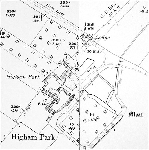
Map of Higham Park, showing the moat
|
The park keeper lived in the Great Lodge which in the late 15thC was recorded as having within it a hall, chapel, chamber, kitchen, a brewhouse and a bake house. A dovecote and two fishponds lay in the grounds whilst a smaller lodge stood on the south side of the park. The Great Lodge fell into decay although the moat which surrounded it, enclosing about one and a half acres, is still preserved near to the present farmhouse (17thC) and the area is a Scheduled Ancient Monument. The Great Lodge was also used for the Rushden manorial court in the 14thc. Nothing remains of the small southern lodge.
The park must have been well wooded with areas of lawn for growing hay for winter feed for the deer. The accounts record felling trees, oak for repairs to the castle drawbridge and Higham mill, crabtrees for replacing broken wheel cogs and 91 oaks were felled in 1433 for repair and construction to the Great Lodge buildings, the fishstalls in Higham market and the mills of Higham.
Deer were still recorded in the park in 1649 although the castle at Higham had long decayed, and the Park seems to have been formally disparked between 1649 and 1672 when Sir Robert Long paid £800 for the grant in free socage of Higham Ferrers Park and its appurtenances.
The land within the boundary of the park has remained as farmland, the names of the closes reflecting its former use, but many of the internal hedgerows were removed during the last century to create larger fields. The park pale is still visible around much of the park and particularly so on the east and south sides. On the western side the ditch is shallow and in some places almost non existent. However the whole boundary of the deer park is fully discernible on the ground and its footprint is clearly defined on maps.
Sources:
| W.J.B. Kerr 'Higham Ferrers and its Ducal and Royal Castle and Park', 1925; |
| Victoria County History, Northamptonshire, Vol.3, 1925; |
| RCHM 'An Inventory of the Historical Monuments of Northamptonshire', Vol.I, 1986; |
| J. Bridges 'History and Antiquities of Northamptonshire, Vol 2, 1791; |
| CBA Group 9 Newsletter, 1974; |
| 'Northamptonshire Past and Present', Journal of the Northamptonshire Record Society, Vol V, 1975; |
| M. Beresford 'History on the Ground', 1971; |
| D. Hall and R. Harding 'Rushden, A Duchy of Lancaster Village', 1985; |
| Saxton's Map of Northamptonshire, 1576; |
| Speed's Map of Northamptonshire, 1610; |
|
|